 Transit Maps USA v.1.2.0.0
Advertisement
Description
NEW TRIAL FUNCTIONALITY - TRY BEFORE YOU BUY!
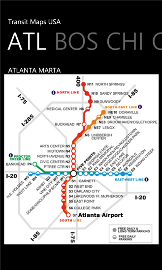
The only Transit Maps app of its kind. You can select the city you want to see the transit maps for and zoom in to view the map in detail on the full screen. You can easily zoom-in, pan, and zoom-out using one hand only. You can now plan your trip from anywhere, any time - no Internet/data connection required. Imagine having the ease of mind that you will always know what line to catch to...
Read more
- Rate:
- Release Date:08/05/2012
- License:Shareware
- Category:Recreation
- Developer:Paras Wadehra
- Downloads:30
- Size:3 Mb
- Price: -
To free download a trial version of Transit Maps USA, click here
To visit developer homepage of Transit Maps USA, click here
Advertisement
Screen Shot
Click on a thumbnail for the larger image.
System Requirements
Transit Maps USA requires Windows Phone 7 or higher | owner identity, data services, HD720P (720x1280), WVGA (480x800), WXGA (768x1280) | English
Transit Maps USA v.1.2.0.0 Copyright
Shareware Junction periodically updates pricing and software information of Transit Maps USA v.1.2.0.0 full version from the publisher using pad file and submit from users. Software piracy is theft, Using crack, password, serial numbers, registration codes, key generators, cd key, hacks is illegal and prevent future development of Transit Maps USA v.1.2.0.0 Edition. Download links are directly from our publisher sites. Links Transit Maps USA v.1.2.0.0 from Bittorrent, mediafire.com, uploadfiles.com, hotfiles.com rapidshare.com, megaupload.com, netload.in, storage.to, depositfiles.com and other files hosting are not allowed. The download file is obtained directly from the publisher, not from any Peer to Peer file sharing applications such as Shareaza, Limewire, Kazaa, Imesh, eDonkey, eMule, Ares, BearShare, Overnet, Morpheus, BitTorrent Azureus and WinMX.
Review This Software
More Transit Maps USA Software
Advertisement


Transit Maps Free v.1.1.0.0
The only Transit Maps app of its kind. You can select the city you want to see the transit maps for and zoom in to view the map in detail on the full screen. You can easily zoom-in, pan, and zoom-out using one hand only.

KL Transit Map by SC v.1.0.0.0
Kuala Lumpur Transit Maps. A must have apps if you visit to Kuala Lumpur, Malaysia. You can easily zoom-in, pan, and zoom-out.

Transit v.1.1.0.0
TRANSIT has been developed with the everyday public transportation commuter in mind. v1.1: • Minor stability and bug fixes • Revamped error logging and reporting This application offers Washington, DC Metro area transportation information and
GeoclipSolo v.2.5.0.33
Géoclip Solo includes a building tool which is described above. It also includes a base map conversion tool (see picture opposite). The geographic layers which are assembled to build a géoclip are in the swf format.
USA Photo Maps v.2.77
USAPhotoMaps downloads USGS (United States Geodedic Survey) aerial photos from terraserver.microsoft.com and creates scrollable, zoomable, GPS-enabled maps from them.
USA Real Estate Map Pro v.2.0
USA Real Estate Map Pro is a premium class software for mapping: real estate properties, contact listings, offices and other geo spatial data.

Golden SpotsMap of USA
Golden SpotsMap of USA for websites, presentations and more. The map contains detailed maps of each state. Features: Driven by XML interface; - Color, URL linking, captions and more. And you can do all these; - Intuitive Flash Map Interface; - Ease of

Major USA cities and highways
USA Cities and Highways Map is a rather simple version of professional software with several background images and a nice monitor glass projection. With our user-friendly USA Cities and Highways Map it is possible to: " add/remove

USA Real Estate Map
USA Real Estate (RE) Map dynamic solution to: - show RE data as a bright map instead of long lists - show info in any sphere other than RE as long as it is shown on state/county level - show info by changing state colors, show tooltips and
Flash USA Map v.1 8
An interactive Flash USA map with all the features you need for your web site or project. This is the ideal solution for dealer maps, real-estate listings, or visualizing state statistics. Nearly every aspect of the map is customizable. However,

Transit Directions v.1.1.0.0
Easily get directions from A to B using public transit! This app is nearly identical to the native maps application, adding in the much-needed abilty to get directions around the city using trains and buses. The app currently services the following
Other products of this developer Paras Wadehra

NPR RSS Reader v.1.1.0.0
NPR News - Now you can have your news on the go....y, just select "open in ie" from the menu at the

SketchPad v.1.2.0.0
***** SHOWCASED IN APP HIGHLIGHTS BY NOKIA AT #1...on your device using a vast color palette and to

Transit Maps Free v.1.1.0.0
The only Transit Maps app of its kind. You can s... zoom-in, pan, and zoom-out using one hand only.